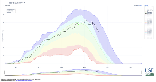
Western Washington’s cold and wet spring continues, as record amounts of rain and low temperatures contribute to high snowpack in north Puget Sound.
On June 7, snowpack levels reached 157% of normal in the Nooksack River basin, according to data available from the United States Department of Agriculture’s (USDA) Natural Resources Conservation Service.
“We definitely are holding the snow up there,” said Scott Pattee, a water supply specialist at the USDA’s office in Mount Vernon. “It’s just the cold temperatures and the cool, wet weather we’ve seen this spring.”
Across the region, snowpack levels remain high late in the season, with the Olympic region reporting levels 538% of normal, and the Central Puget Sound region at 224% of normal on June 7.
 Snowpack in North Puget Sound is significantly higher than normal following a cold, wet spring. This means more water in the rivers as the snow melts and great news for farmers and fish. (Graphic courtesy of the United States Department of Agriculture)
According to the Environmental Protection Agency, snowpack plays “a key role in the water cycle in western North America, storing water in the winter when the snow falls and releasing it as runoff in spring and summer when the snow melts.”
In Whatcom County, that runoff contributes to the Nooksack River and all the surrounding bodies of water, providing much-needed water for farming, irrigation and daily consumption.
The late snowpack in the region is good news for local fish populations and farmers, Pattee said, who both struggled significantly during last summer’s heat wave and drought. When temperatures spiked to more than 100 degrees last June, the snowpack melted rapidly, and drought devastated the region’s farms and fish populations.
“Last year, we did have a problem,” Pattee said. “The water levels dropped down really early because it got really hot.”
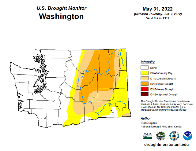
Pattee said there are no forecast models predicting another unusually hot summer this year, and the U.S. Drought Monitor, produced by the University of Nebraska, the USDA and the National Oceanic and Atmospheric Administration (NOAA) said Thursday there are no drought conditions in Western Washington.
 The U.S. Drought Monitor, produced by the University of Nebraska-Lincoln, the United States Department of Agriculture and the National Oceanic and Atmospheric Administration (NOAA), shows risks of severe drought across central Washington, though no risk in western Washington, including in Whatcom County. (Graphic courtesy of the U.S. Drought Monitor)
This year, the late melt will contribute to higher stream flows later in the summer.
“It’ll help sustain stream flows longer and better throughout the spring and summer, which is going to be great for fisheries and recreationists,” Pattee said. “It looks like there should be plenty of water this year for all uses.”
While the snowpack levels may seem high, in reality, the region’s melt was just delayed by the cold spring conditions. Typically, the snowpack in the North Puget Sound region peaks right around April 15 each year, Pattee said, but this year, the snowpack peaked May 5.
“Our melt-out should be at least two to three weeks later than normal,” Pattee said. “It seems like we’re way above normal, but it’s not as much the case, and it’s more about the timing of the melt.”


