A category 4 atmospheric river will bring heavy rains, snow and potential floods back to Western Washington this week.
Atmospheric rivers, massive streams of water vapor moving through the sky, are rated on a scale of one to five, with a category one bringing beneficial rainfall and a category five producing “exceptional” and “hazardous” storms, according to the Scripps Institution of Oceanography at the University of California San Diego.
On Monday, Seattle’s office of the National Weather Service (NWS) announced a flood watch in Whatcom County, in effect until Wednesday afternoon.
“The current atmospheric river affecting Western Washington has most all the components that contribute to flooding,” according to a release from NWS. “All this, together with the longevity of the pattern, is producing high rainfall accumulations and periodic high rain rates.”
The heaviest rains are likely to occur south of Whatcom, according to local weather expert Randy Small.
“I’m hesitant to say we’re out of the woods 100 percent, because we’ll still have a couple of days of rain,” he said. “At this point, though, we’re in pretty good shape.”
Parts of Skagit County could see significant floods, with a predicted 29 foot crest of the Skagit River in Concrete on Tuesday, according to the Northwest River Forecast Center.
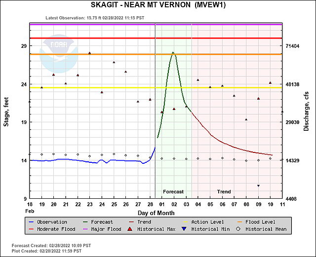 Flooding and river forecast for Skagit County from the Northwest River Forecast Center, a division of National Oceanic and Atmospheric Administration (NOAA). (Northwest River Forecast Center)
Flood anxieties remain high in Whatcom County following catastrophic flooding in November and December, when record-breaking rains and floods caused more than $50 million in damage. Several FEMA disaster recovery centers remain in the area, and more than 900 households have been approved for grants and assistance funds.
The 2021 floods that wrought such damage were caused by five atmospheric rivers in rapid succession following a particularly rainy month, Small said.
“November was much wetter prior to the major historic flood. February’s rain total is well below normal,” he said. “We have 1.09 inches, versus almost a 3-inch normal, so that tells me February is dry.”
Small looks at several environmental factors to determine flood risk levels, including average rainfall and river flood gauges.
Because February was so dry, river levels have remained low leading into this atmospheric river, lessening the risk of extreme floods.
Avalanche risks, though, are high across the Cascade range following significant snowfall Sunday, but Small says the increased snow will help prevent additional river flooding.
“Snow levels are starting to rise: Baker got 19 inches of snow in a 24 hour period between 6 a.m. [Sunday] and 6 a.m. [Monday],” Small said. “That will help absorb all this rain like a sponge.”
Small isn’t stressed about catastrophic floods hitting Whatcom this week.
“The only thing that would concern me would be localized, urban flooding,” he told CDN.
Current flood warnings are set to expire Thursday, March 3.